- Images
- Blog
- Tools
- Questar
- The Questar telescope
- Questar resource links
- Search for Questar info
- 172mm Focal Reducer
- Afocal adapter for point and shoot camera
- Camera adapter lengths
- Camera adapter threading
- Camera connection
- Camera focusing
- Custom counterweight
- Drift Alignment Joy
- Finder Eyepiece Compatibility
- The Questar Moon 1981
- Questar Powerguide II Battery Life
- Questar Zone, How to Service Videos
- Red Dot finder mount for Questar
- Questar Viewing Table
- Wedge mounts
- White light solar filters comparison
- How to
- Get started in astronomy
- Astro RaspberryPi Camera and kin, the ASIAir and StellarMate
- Blind Smart-phone Equatorial Wedge or GEM Polar Alignment
- Camera phone adapter
- Celestron FirstScope with equatorial tripod mount
- Coat Pocket Astrophotography
- Day-lapse Images of Earthshine on the Crescent Moon
- Dobsonian Carrying Case
- DSO Astrophotography without a Telescope
- DSO imaging without a star tracker
- Estimating image resolution
- Lunar Eclipse Photography
- Moon photography - a dozen ways to shoot the Moon
- Meteor shower photography & planning
- Matching image sensor size to telescope resolution
- Narrow band imaging with color cameras
- Planetary Image Workflow
- Print and Display Astrophotography
- Observing
- Events
- More
- About
- Contact
NWS Interactive Digital Forecast Map
The National Weather Service has a new interactive map of their National Digital Forecast Database. This tool does a great job of visualizing how weather will develop on an hour by hour basis over the next week. Sixteen different measurements can be displayed including: temperatures, dew point, sky cover, and precipitation. Over time, they plan to phase out some of their existing web tools in favor of this.
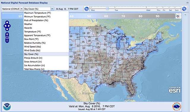
I've added this tool to the Forecast page so that it is easily at hand. It starts up showing sky cover over Texas.
Content created: 2016-08-08

Comments
![]() Submit comments or questions about this page.
Submit comments or questions about this page.
By submitting a comment, you agree that: it may be included here in whole or part, attributed to you, and its content is subject to the site wide Creative Commons licensing.

Blog
Silver City Heart & Soul Nebulae Revisited
Medulla or Garlic Nebula, CTB1, Abell 85
Nebulae afire off the belt of Orion
City Lights Horsehead & Flame Nebulae
Flaming Star Nebula dark sky vrs city sky face-off
Christmas Tree Cluster and Cone Nebula with more exposure
Christmas Tree Cluster with the Cone Nebula
Horsehead Nebula Face-Off Bortle 2 vrs Bortle 7
California Nebula Face-Off Bortle 2 vrs Bortle 7
Western Veil Nebula from Marfa
Trifid and Lagoon Nebulae Drizzle Stacked
North America and Penguin Nebulae Drizzle Stacked
Return to Coconino Andromeda, M31
Revisiting the Willow House Rosette
Corazón Incendida, the Heart Nebula
Elephant Trunk with the Garnet Star
Balanced HO North America & Pelican Nebulae
The Lagoon & Trifid Nebulas from Marfa
Western Veil Nebula from Marfa
The Great Winter Solstice Conjunction of Jupiter and Saturn
Two days to the Great Jupiter Saturn Conjunction
Worlds Apart, the Jupiter Saturn Conjunction
Raspberry Pi HQ camera first light
Waxing Crescent Moon with earthshine and stars
Vixen Porta II mount adapter or aluminum disk with holes #2
The 2019 ACEAP Expedition to Chile
Universe of Stories: Getting Started in Astronomy
View an Apollo flag on the Moon from Earth?
Apollo 50th is my 24th Flickr Explore Selection
Shooting the video stars - Moon and Jupiter
Ready for a change in perspective
Jupiter and the Galilean Moons through a camera lens
2022 the Solar System in one view
As hard to see as a doughnut on the Moon
Santa Inez miners church Terlingua
Waning gibbous Moon early Christmas Eve
Christmas eve on the eastern limb of the Moon
Mars at 23.3 arc sec with Syrtis Major
BadAstroPhotos Web Site Analytics
Saturn with Pixinsight workflow
Mars Update from Mauri Rosenthal
Waxing Gibbous Moon Terlingua Texas
Io Transit of Jupiter with the Great Red Spot
Not so bad Astro after 2 years
Eyes of the Llama from Urubamba
Moon and Venus over Cusco's El Monasterio
Tiangong-1 Space Station reentry tracking
Apollo - 50 years of human footprints on the Moon, complete!
Waxing Crescent Moon after Astrophotography Meetup
The Great American Eclipse from Above and Below
A million astro photo views on Flickr
Ansel Adams: Moonrise, Hernandez, New Mexico
December Solstice Crescent Moon with Earthshine
January 31 Blue Moon Lunar Eclipse
The Total Solar Eclipse in half a minute
2017 Solar Eclipse from a million miles away
Longhorn Eclipse from a Wyoming Hilltop
Fibs, damn lies, telescopes, and astrophotography
Full Moon before Total Solar Eclipse 2017
Longhorn Crescent Moon from Austin
The Crescent Moon with Jupiter and moons
Eye of the storm 2 - Juno & Jupiter's Great Red Spot
Eye of the storm - Juno & Jupiter's Great Red Spot
A million miles from earth, the Moon and earth east and west
Saturn with Titan, Dione, Tethys, & Rhea
Animated transit of Jupiter by Io
Solar Eclipse 2017 Highway Traffic Map
Mid-South Star Gaze + Questar Meet
Sweet Home Alabama Transit of Jupiter by Io
Update on AutoStakkert on macOS
Diffraction is not the limit for digital images
Teasing life into planetary images
Moon camera comparison: DSLR & planetary cameras
Waning Crescent Moon with Earthshine
1st day of Spring last quarter Moon
Lewis Morris Rutherfurd's Moon
Super Moonrise over Lady Bird Lake
360 Tower pierces the Super Moon
Lisbeth's Birthday Crescent Moon
The Moon and Mars from the Astro Café
Silent and Mechanical Shutter Comparison
Austin's Solar Sidewalk Sun-Day
Another Longhorn Moon over Austin
Jupiter and Venus do a father-daughter dance
Sunset with Mercury, Jupiter, and Venus
Mercury, Jupiter & Venus after sunset
3 months, 92 nations, 3750 visitors, 100,000+ images served
Upcoming Conjunction of Jupiter & Venus
The Perseid Meteor Shower with the Andromeda Galaxy
Waxing crescent Moon from UHD Video
NWS Interactive Digital Forecast Map
M7 the Ptolemy Cluster preview
Five Planets in the Sky at Dusk
Lucky Fat Waning Crescent Moon
Two months, 80 nations, and an embarrassing bug
Saturn with 5 moons: Titan, Rhea, Enceladus, Tethys, & Dione
The nearly full Moon and Saturn with a short tube refractor

Made with care using XML on a Mac in Austin, Texas on
2026-07-14
© 2026 Robert C. Pettengill,
Ph.D. 