- Images
- Blog
- Tools
- Questar
- The Questar telescope
- Questar resource links
- Search for Questar info
- 172mm Focal Reducer
- Afocal adapter for point and shoot camera
- Camera adapter lengths
- Camera adapter threading
- Camera connection
- Camera focusing
- Custom counterweight
- Drift Alignment Joy
- Finder Eyepiece Compatibility
- The Questar Moon 1981
- Questar Powerguide II Battery Life
- Questar Zone, How to Service Videos
- Red Dot finder mount for Questar
- Questar Viewing Table
- Wedge mounts
- White light solar filters comparison
- How to
- Get started in astronomy
- Astro RaspberryPi Camera and kin, the ASIAir and StellarMate
- Blind Smart-phone Equatorial Wedge or GEM Polar Alignment
- Camera phone adapter
- Celestron FirstScope with equatorial tripod mount
- Coat Pocket Astrophotography
- Day-lapse Images of Earthshine on the Crescent Moon
- Dobsonian Carrying Case
- DSO Astrophotography without a Telescope
- DSO imaging without a star tracker
- Estimating image resolution
- Lunar Eclipse Photography
- Moon photography - a dozen ways to shoot the Moon
- Meteor shower photography & planning
- Matching image sensor size to telescope resolution
- Narrow band imaging with color cameras
- Planetary Image Workflow
- Print and Display Astrophotography
- Observing
- Events
- More
- About
- Contact
Astronomical Forecast Dashboard
A Visual Dashboard of the Best Weather Forecasts for Astronomers
Save time with at-a-glance forecasts and shortcuts to the exact astronomical weather information needed for Texas, North America, and world wide. All of the hard work is done by others, I built this page to save me time drilling down though website menus to get what I need.
Some of these tools are interactive 3rd party widgets that may not work correctly on legacy browsers or operating systems. I test this page in iOS and with a recent version of Safari, Chrome, and Firefox on macOS. To customize this page to your own needs, please see the customization instructions at the bottom of this page.
Extended forecasts for Austin Astronomers
National Weather Service Graphical Interactive Sky Cover Forecast Map
National Weather Service Extended Forecast Chart
Astrospheric forecasting for North American astronomers
Clear Dark Sky Astronomical Forecast

Clear Dark Sky Forecast History / Climate Information
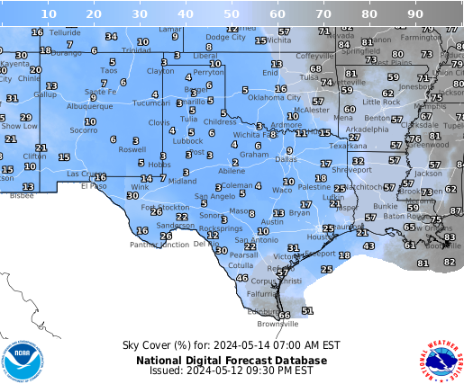
NWS Sky Cover Forecast for Texas
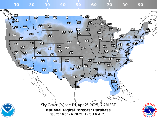
Forecasts for the United States
NOAA Water Vapor Satellite
NOAA IR Satellite
Smoke and Dust
Saharan & North American Dust
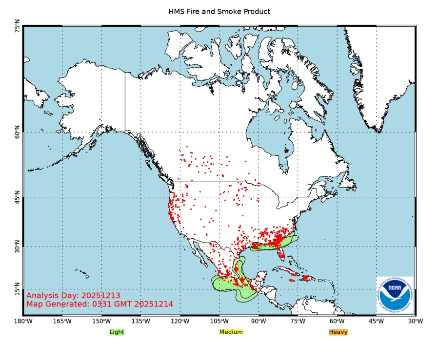
Wildfire Smoke Plume Map
Also available, the NOAA HRRR-Smoke interactive map
Longer Range US Forecasts
These forecasts are relative to the normal precipitationfor the indicated period.
6-10 Day Outlook for Precipitation
8-14 Day Outlook for Precipitation
14-28 Day Outlook for Precipitation
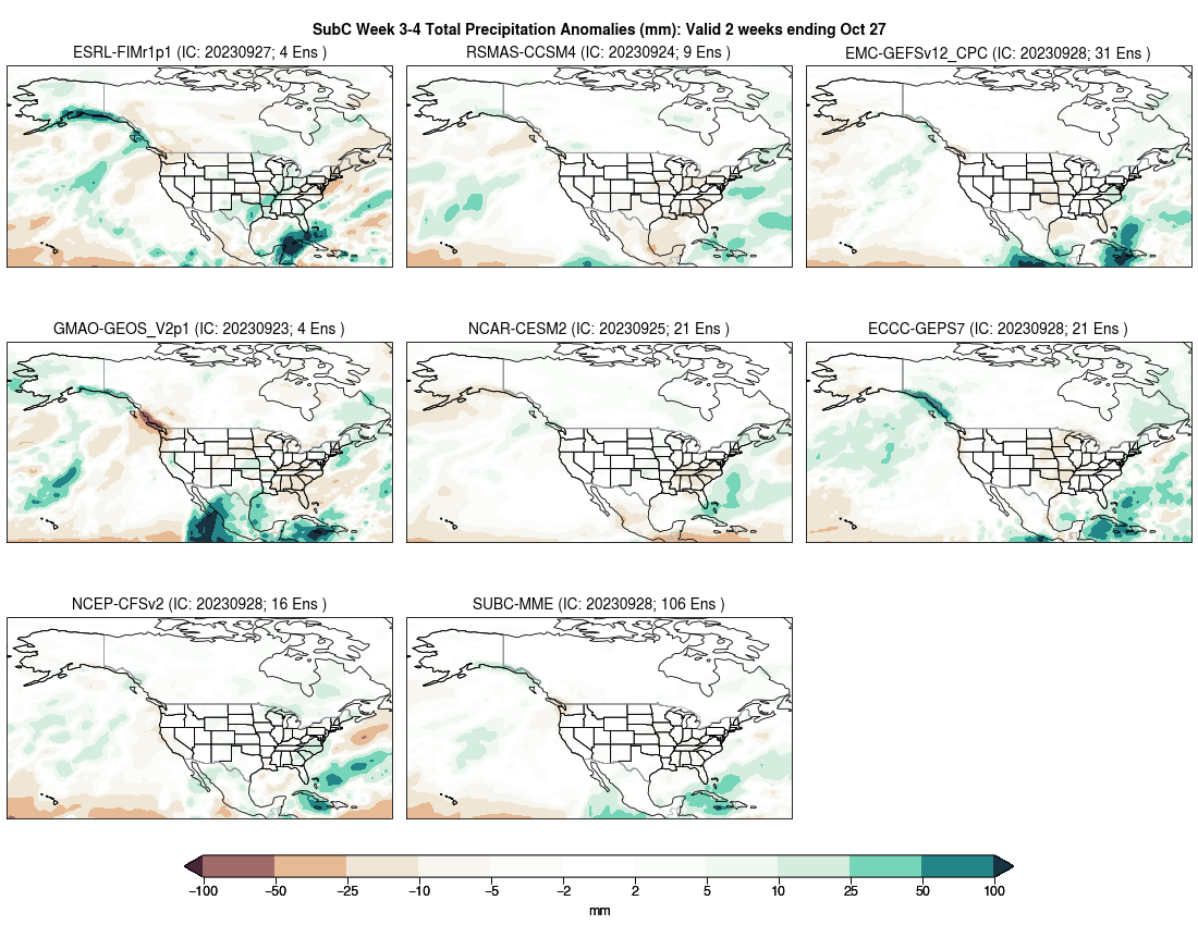
SubX 3-4 week Subseasonal eXpermintal forecasts
SubX is a large ensamble model from George Mason University and the University of Miami that is showing success with long range forecasts. The image below shows individual component forecasts, with the SubX ensamble last. Follow the link for a detailed interactive version.
Seasonal Outlook for Precipitation
Locations that I'm interested in
Capulin - Clayton, New Mexico - chart or
map

Enchanted Rock Natural Area, Texas - chart or
map

Flagstaff, Arizona - chart or
map

French Camp, Mississippi - chart or
map

Holly Springs, North Carolina - chart or
map

Lake Tahoe, California - chart or
map

Marathon, Texas - chart or
map

Pedernales Falls State Park, Texas - chart or
map

Silver City, New Mexico - chart or
map

Terlingua / Big Bend, Texas - chart or
map

Meteoblue World Wide Astronomical Seeing
Meteoblue has good coverage outside of North America. North America specific forecasts from other sources may be more accurate.
Customization
If you have a little knowledge of HTML markup you can easily customize this page to your own needs. You might want to change locations for forecasts, add other forecasts that you use, or avoid loading ones that you don't use or that don't work with your computer. To do this:
- Save this page to your local computer's desktop. In most browsers this will be done from the main menu File menu via "Save As..." or something similar like "Save Page As..."
- Open the file you saved in a text editor and add the following text to
the <head> section of the document near the top:
<base href="http://astronomy.robpettengill.org/" /> - Now you can make any customizations you want to the file and it will still be able to find style sheet and image resources on this site.
- Save your modified file.
- When you open the saved file, it should open in your browser with your modifications.
- Your are welcome to host your modified page on your own web site with an acknowledgement and link back to this page.
Content created: 2016-05-18 and last modified: 2023-11-13
Comments
![]() Submit comments or questions about this page.
Submit comments or questions about this page.
By submitting a comment, you agree that: it may be included here in whole or part, attributed to you, and its content is subject to the site wide Creative Commons licensing.

Observing
Astronomical Forecast Dashboard
City Park Road Turkey Creek trail head
Dripping Springs, Wimberly, Johnson City
Fountainwood Observatory Southwestern University
Liberty Hill, Oatmeal, Bertram
Mexican American Cultural Center
Northwest Balcones / Talleyran Park
Shin Oak Observation Deck, Balcones Canyonlands
Texas Local Parks and Rest Areas
3 Rivers Foundation Comanche Springs Astronomy Campus
Aransas Naitonal Wildlife Refuge
Devils River State Natural Area
Devil's Sinkhole State Natural Area
Fort Griffin State Historic Site
Guadalupe Mountains National Park
Hill Country State Natural Area
Lost Maples State Natural Area
McDonald Observatory / Davis Mountains
Medina County Texas 173 Rest Stop between Bandera and Hondo


 Austin Urban Stargazing