Eclipse 2024 forecasts at a glance
This dashboard will reflect the most useful information as eclipse day approaches. You can bookmark it now for later when you will need detailed eclipse weather forecasts.
The April 8, 2024 total solar eclipses will be visible in a wide swath across North America, with best weather likely in Texas or in Mexico. Moving to a spot with the clearest predicted weather, before the event, will increase your chances of a clear view.
These resources can help eclipse observers up their chances of clear skies, with the latest data, in the last few days before the eclipse. Detailed forecasts for a few large cities near the path of totality are included. Images are linked to the original source for more detailed or up-to-date data. You can navigate to local data for other locations or times.
The web sites with the original weather data can be slow to load and navigate under normal circumstances. They may become slower as the eclipse approaches. A page that cuts through the navigation and fluff to just the data you need in one spot can be a time saver. I tailored this page for myself, friends, and family in Texas. If the data and locations on this page are not exactly what you need, feel free to copy and use it as a template for your own custom eclipse weather page. Jay Anderson's Eclipsophile includes an expert survey and analysis of available resources.
Eclipse Day Forecasts
These interactive tools provide the latest high resolution modeling information during the last couple of weeks leading up to the eclipse. You can fine tune them by using your own location appropriate time frame:
Pivotal Weather Eclipse Day Forecasts.
SpotWx graphical weather model display - check GFS (10 days out), NAM (3.5 days out), HRDPS (2 days out), & HRRR (18 hours).
College of DuPage NeXt Generation Weather Lab has HRRR average total cloud cover forecasts useful the day before the eclipse:
National Forecasts
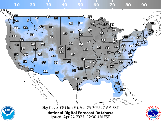
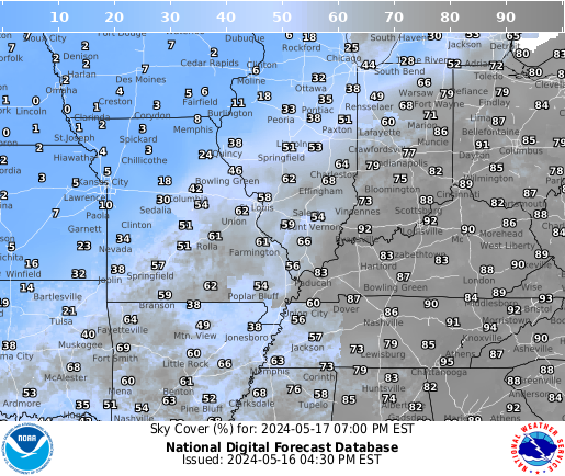
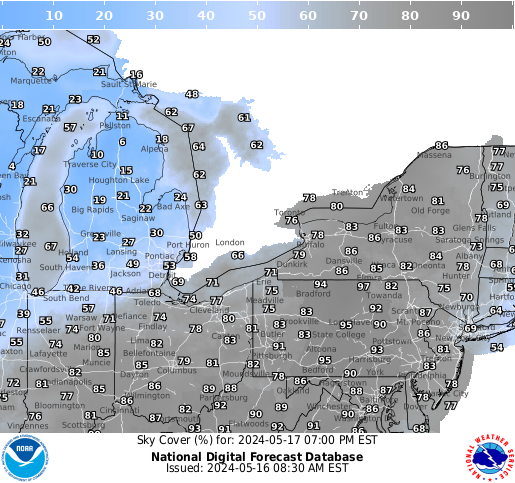
NOAA Sky Cover Observations and Forecasts ( image selection)

Local forecasts along the 2024 Total Solar Eclipse path
These are most usefull the last couple of days
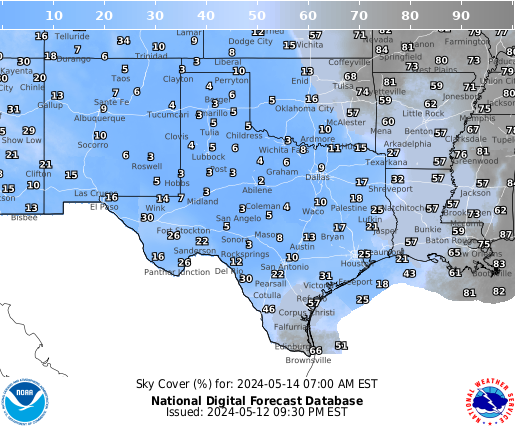
Texas
Ensamble cloud forcast from Astrospheric
The animation below shows the last 3 days before the eclipse. The path of totality is shown in green. Clouds from the Canadian RDPS Model (often most accurate for clouds) are shown in blue, clouds from the American NAM model are shown in green, and clouds from the American GFS model are in red. Where all the models agree clouds will be present clouds appear white. Where none of the models predict clouds the image is transparent/dark.

NWS Sky Cover Forecast for Texas, Okalahoma, & Arkansas
Austin
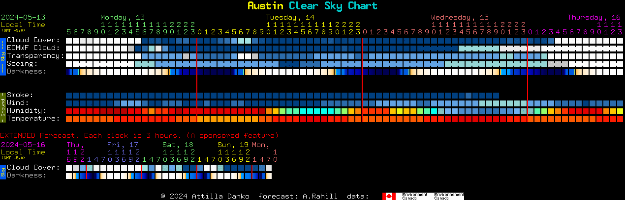
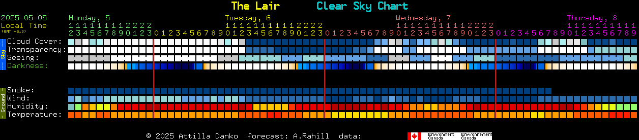
Clear Dark Sky Forecast History / Climate Information
Eagle Pass

Clear Dark Sky Forecast History / Climate Information
Uvalde

Clear Dark Sky Forecast History / Climate Information
Kerville, Bandera, Hill Country State Natural Area

Clear Dark Sky Forecast History / Climate Information
Fredericksberg, Enchanted Rock
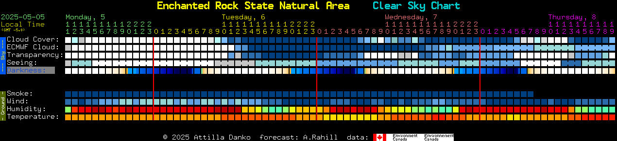
Clear Dark Sky Forecast History / Climate Information
Lampassas
Clear Dark Sky Forecast History / Climate Information
Waco

Clear Dark Sky Forecast History / Climate Information
Dallas

Clear Dark Sky Forecast History / Climate Information
Sulphur Springs

Clear Dark Sky Forecast History / Climate Information
Arkansas
Little Rock
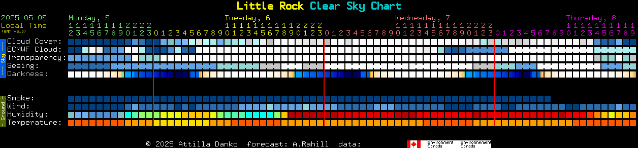
Clear Dark Sky Forecast History / Climate Information
NWS Sky Cover Forecast for Central Mississippi Valley
Indiana
Indianapolis

Ohio
NWS Sky Cover Forecast for East Great Lakes
Cleveland

New York
Buffalo

Vermont
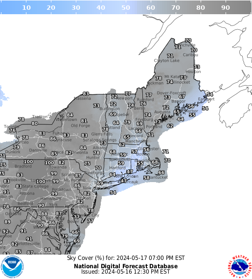
NWS Sky Cover Forecast for Northeast
Burlington

Maine
Houlton

Newfoundland
Gander

Content created: 2020-02-02 and last modified: 2024-04-05

Comments
![]() Submit comments or questions about this page.
Submit comments or questions about this page.
By submitting a comment, you agree that: it may be included here in whole or part, attributed to you, and its content is subject to the site wide Creative Commons licensing.


Made with care using XML on a Mac in Austin, Texas on
2026-07-14
© 2026 Robert C. Pettengill,
Ph.D. 