- Images
- Blog
- Tools
- Questar
- The Questar telescope
- Questar resource links
- Search for Questar info
- 172mm Focal Reducer
- Afocal adapter for point and shoot camera
- Camera adapter lengths
- Camera adapter threading
- Camera connection
- Camera focusing
- Custom counterweight
- Drift Alignment Joy
- Finder Eyepiece Compatibility
- The Questar Moon 1981
- Questar Powerguide II Battery Life
- Questar Zone, How to Service Videos
- Red Dot finder mount for Questar
- Questar Viewing Table
- Wedge mounts
- White light solar filters comparison
- How to
- Get started in astronomy
- Astro RaspberryPi Camera and kin, the ASIAir and StellarMate
- Blind Smart-phone Equatorial Wedge or GEM Polar Alignment
- Camera phone adapter
- Celestron FirstScope with equatorial tripod mount
- Coat Pocket Astrophotography
- Day-lapse Images of Earthshine on the Crescent Moon
- Dobsonian Carrying Case
- DSO Astrophotography without a Telescope
- DSO imaging without a star tracker
- Estimating image resolution
- Lunar Eclipse Photography
- Moon photography - a dozen ways to shoot the Moon
- Meteor shower photography & planning
- Matching image sensor size to telescope resolution
- Narrow band imaging with color cameras
- Planetary Image Workflow
- Print and Display Astrophotography
- Observing
- Events
- More
- About
- Contact
Eclipse 2017 forecasts at a glance
The August 21, 2017 eclipse will be visible under clear skies from many places in the US. Moving to a spot with the clearest predicted weather, before the event, will increase your chances of a clear view.
These resources can help eclipse observers up their chances of clear skies, with the latest data, in the last few days before the eclipse. Detailed forecasts for a few large cities near the path of totality are included. Images are linked to the original source for more detailed or up-to-date data. You can navigate to local data for other locations or times.
The web sites with the original weather data can be slow to load and navigate under normal circumstances. They may become slower as the eclipse approaches. A page that cuts through the navigation and fluff to just the data you need in one spot can be a time saver. I tailored this page for myself, friends, and family. If the data and locations on this page are not exactly what you need, feel free to copy and use it as a template for your own custom eclipse weather page. Jay Anderson's Eclipsophile includes an expert survey and analysis of available resources.
National Forecasts
SpotWx graphical weather model display - check GFS (10 days out), NAM (3.5 days out), HRDPS (2 days out), & HRRR (18 hours).
College of DuPage NeXt Generation Weather Lab HRRR average total cloud cover forecast for eclipse day:
NOAA Sky Cover Forecast for eclipse day ( old interface)
Intellicast SkyWatch - 8 hours ahead shown below, follow the link for forecasts up to 2 days ahead.
National Overviews of Current Weather
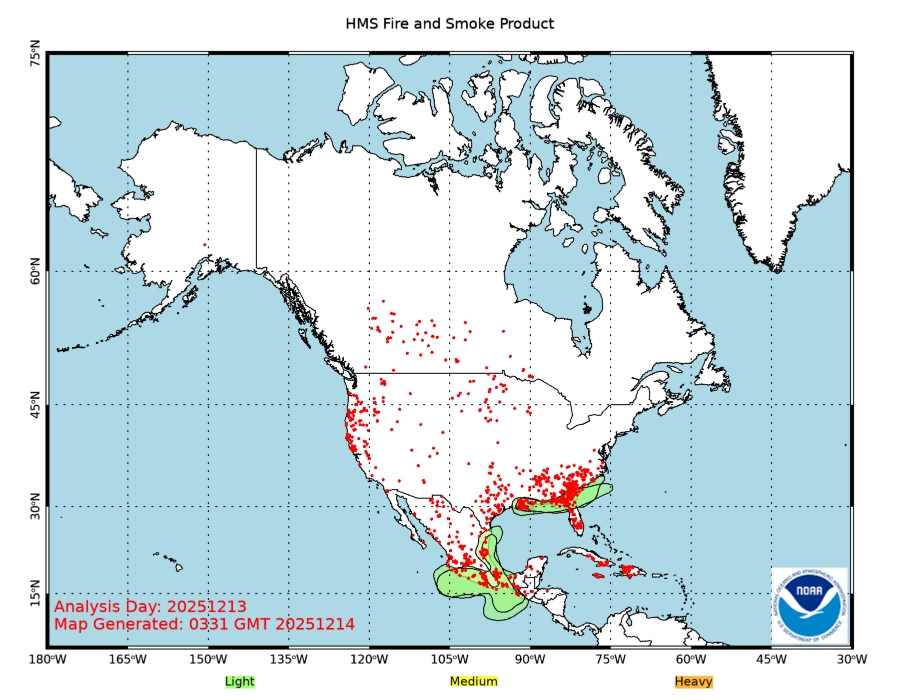
Wildfire Smoke Plume Map
The EPA AirNow site has an interactive map that shows smoke plumes from wildfires in North America. Current data from NOAA is shown below:
NOAA Water Vapor Satellite
NOAA IR Satellite
NOAA Visible Satellite
Nebraska
Nebraska 511 Traveler Information
Satellite Infrared and Visible with loop from NeXt Generation Weather Lab
Sky Watch - 8 hours ahead shown below, follow the link for forecasts up to 2
days ahead.

Hourly extended forecasts for Grand Island
National Weather Service Graphical Interactive Sky Cover Forecast Map
National Weather Service extended forecast
Missouri
Missouri DOT Traveler Information
Satellite Infrared and Visible with loop from NeXt Generation Weather Lab
Sky Watch - 8 hours ahead shown below, follow the link for forecasts up to 2
days ahead.

Hourly extended forecasts for St Louis
National Weather Service Graphical Interactive Sky Cover Forecast Map
National Weather Service extended forecast
Oregon
Oregon DOT Traveler Information
Satellite Infrared and Visible with loop from NeXt Generation Weather Lab
Sky Watch - 8 hours ahead shown below, follow the link for forecasts up to 2
days ahead.

Hourly extended forecasts for Salem
National Weather Service Graphical Interactive Sky Cover Forecast Map
National Weather Service extended forecast
South Carolina
South Carolina 511 Traffic Information
Satellite Infrared and Visible with loop from NeXt Generation Weather Lab
Sky Watch - 8 hours ahead shown below, follow the link for forecasts up to 2
days ahead.

Hourly extended forecasts for Columbia
National Weather Service Graphical Interactive Sky Cover Forecast Map
National Weather Service extended forecast
Tennessee
Satellite Infrared and Visible with loop from NeXt Generation Weather Lab
Sky Watch - 8 hours ahead shown below, follow the link for forecasts up to 2
days ahead.

Hourly extended forecasts for Nashville
National Weather Service Graphical Interactive Sky Cover Forecast Map
National Weather Service extended forecast
Wyoming
Wyoming 511 Traveler Information
Satellite Infrared and Visible with loop from NeXt Generation Weather Lab
Sky Watch - 8 hours ahead shown below, follow the link for forecasts up to 2
days ahead.

Hourly extended forecasts for Casper
National Weather Service Graphical Interactive Sky Cover Forecast Map
National Weather Service extended forecast
Content created: 2017-05-10 and last modified: 2017-08-17
Comments
![]() Submit comments or questions about this page.
Submit comments or questions about this page.
By submitting a comment, you agree that: it may be included here in whole or part, attributed to you, and its content is subject to the site wide Creative Commons licensing.


 ACEAP
ACEAP
